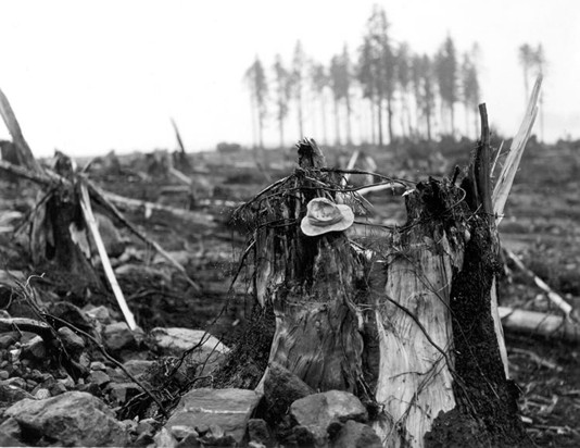
In planning for future tsunami response in Alaska, how much do you and your colleagues rely on data/studies/first-person accounts of events like the 1958 earthquake and tsunami in Lituya Bay? Lituya Bay was an anomaly, presenting perfect conditions for the creation of a megatsunami. This catastrophic event occurred as a result of an 8.2 magnitude earthquake, which triggered the dislodging of massive rocks from the northeast shore of Gilbert Inlet. Lituya Bay itself is a narrow bay, spanning a mere two miles in width and extending for seven miles in length, with a maximum depth of 720 feet and an entrance measuring only 33 feet in width. In response to this devastating event, the State of Alaska Division of the U.S. Geological Survey has allocated resources to scientists who are tasked with monitoring potential mountain slopes throughout the state that possess the capacity to fracture and potentially generate tsunamis. Does the response plan for a "megatsunami" like the 1958 event differ from plans for smaller tsunami in the region? The response plan of the Alaska Division of Homeland Security and Emergency Management aligns with standard disaster protocols. In accordance with the projected severity of the situation, our procedures would be expedited, ensuring a comprehensive and coordinated effort. Activation of the State Emergency Operations Center would take place, serving as the hub for collaboration among our partner agencies and the consolidation of all available resources. This collective mobilization signifies an "all hands-on deck" approach to effectively address the challenges at hand. It is crucial to distinguish between local and far-field "megatsunamis" when assessing their impact. In the case of a local tsunami, the community would have approximately one hour to prepare for the impending disaster. It is important to note that local tsunamis pose a significant threat to the population, as authorities have limited time to issue warnings and evacuate residents, potentially resulting in a substantial number of casualties. In such scenarios, our primary focus would involve promptly informing neighboring communities and partnering with relevant agencies to address this imminent danger. It is highly probable that the Governor would enact an executive order for federal assistance to aid in the response efforts. Therefore, it becomes imperative that we allocate appropriate resources and provide comprehensive training to the first responders within these communities, as well as prioritize educating the residents themselves. We have implemented various measures, such as tsunami warning sirens, to equip our communities with early warning systems. In the event of a distant tsunami, wherein there is a lead time of approximately one to three hours before the arrival of the megatsunami, our main objective would be to facilitate the safe evacuation of the community to higher ground. What kind of information do you and your colleagues receive from seismologists that helps you in tsunami planning and response? As the Geohazard Mitigation Coordinator within the Division of Homeland Security and Emergency Management, my role involves working closely with researchers who are consistently engaged in this endeavor. Dmitry Nicolsky, Ph.D. and Elena Suleimani, Ph.D. are esteemed researchers focusing on tsunami inundation mapping for Alaskan communities. They employ numerical models of tsunami wave dynamics to identify coastal areas at high risk of future tsunamis. Their findings are utilized to create community-specific tsunami inundation maps, serving as invaluable resources for local emergency officials involved in evacuation planning and public education initiatives concerning tsunamis. Barrett Salisbury, Ph.D. oversees the Earthquake and Tsunami Hazards program within the State of Alaska Division of Geological & Geophysical Surveys. In this capacity, Barrett's day-to-day operations revolve around public service in the field of earth science, primarily aiming to minimize the impact of future earthquake and tsunami events. A significant aspect of this work involves direct engagement with Alaskans, assisting them in enhancing their resilience through education, planning, mitigation and response. Barrett also serves as a partner in the Alaska branch of the National Tsunami Hazard Mitigation Program and currently holds the position of Chair at the Alaska Seismic Hazards Safety Commission. Dave Snider fulfills the role of Tsunami Warning Coordinator at NOAA's National Tsunami Warning Center, located in Palmer, Alaska. In this position, he collaborates with experts in the field of tsunamis to ensure seamless coordination between NOAA's detection and forecasting of tsunami events and the operations of the National Weather Service and Emergency Alert Systems. It's important to acknowledge the vital support provided by our dedicated staff who assist with the logistical aspects of our projects. In our pursuit of advancing our studies, we regularly conduct fieldwork and travel to rural coastal communities throughout Alaska, engaging with community leaders and first responders. During these outreach events, we collect stories and firsthand accounts from individuals who have experienced previous seismic-related events. In fact, Jeremy Zedick, the public information officer within the Division of Homeland Security and Emergency Management, makes it a priority to conduct interviews with survivors of the Good Friday 1964 Earthquake when accompanying our team on trips. These firsthand encounters enable us to document the historical perspective and enhance the preparedness of these communities, ensuring their resilience in the face of future tsunamis. |