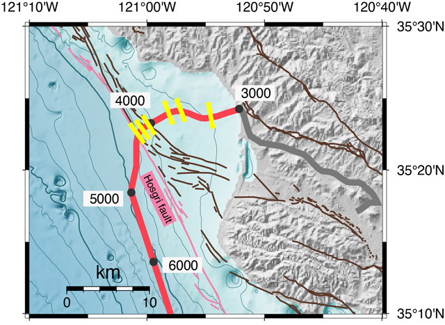
10 January 2025—Using an existing telecommunications fiber optic cable running along the sea floor, researchers identified faults and tracked the locations of whales traveling up and down the central California coast.
Their study, published in Seismological Research Letters, demonstrates the potential of distributed acoustic sensing (DAS) for visualizing the geohazards that could impact deep-water offshore wind energy projects, according to Robb Moss of California Polytechnic State University and colleagues.
Understanding these hazards is essential for safe deployment of offshore wind projects, but the sea floor sediments beneath floating deep-water platforms are rarely mapped. What’s more, the techniques traditionally used to seismically map these regions—usually “active” source methods that often use loud acoustic emissions—can disturb marine life such as migrating whales.
DAS offers a way to develop a high-resolution image of the top 100 meters or so of sea floor sediment while also collecting data on whale calls that can help wind energy companies avoid whale migration paths, the researchers found.
Distributed acoustic sensing or DAS uses the tiny internal flaws in a long optical fiber as thousands of seismic sensors. An interrogator at one end of the fiber sends laser pulses down the cable that are reflected off the fiber flaws and bounced back to the instrument. When the fiber is disturbed by seismic activity, researchers can examine changes in the reflected pulses to learn more about the resulting seismic waves.
Moss along with Zhongwen Zhan of Caltech and two postdoctoral researchers worked with the telecommunications company Zayo to repurpose one of the company’s “dark” or unused fibers that runs south from Morro Bay to Santa Barbara, California. The researchers placed their interrogator in an onshore Zayo “hut” in San Luis Obispo, California. Funding for this research venture was provided by John Gregg of Seafloor Geotech.
Using a year’s worth of DAS data that included both earthquake data and ambient data from sources such as ocean waves, they created a detailed image of the first 3000 to 4000 meters of sediment on the ocean floor beneath the cable. They then focused resolution on the upper 100 meters to look for evidence of faulting.
Data from the earthquakes allowed them to identify a known fault in the Hosgri fault zone, as well as four previously unmapped faults in the Morro Bay area. The researchers also identified the acoustic waves caused by whale calls, using these waves to locate and track whales passing over the cable. On one day, the researchers identified about 260 whale calls and were able to locate about half of the whale callers.

Moss said he and Zhan came up with the idea of using DAS to map offshore wind energy deployment areas at the 2021 Seismological Society of America’s annual meeting, where Zhan gave a presentation on frontiers in DAS technology.
Moss had worked on other California offshore geohazards projects related to energy projects, including liquified natural gas terminals in the early 2000s. As offshore wind energy companies drew closer to launching projects off the California coast, Moss knew they would need to consider potential geohazards and ecological roadblocks in their deep-sea deployment areas.
“We conceived this project with both goals in mind from the start,” said Moss. “We could disrupt the usual way that we study seafloor geophysics and allow us to safely track the whales at the same time.”
Now that their study has shown that it’s feasible to use DAS to map the sea floor and track marine life, Moss said their “phase 2” will be to deploy their own optical fiber to create a more detailed map of the faults, landslides, turbidites and other hazards that could affect a floating deep-water platform anchorage. The researchers are also interested in working with marine biologists to share and further develop their whale call analysis.
“This is a region that has very little mapping, in terms of sea floor geophysics,” explained Moss, “so none of the transoceanic telecom cables go through this region, and that’s why we want to do a deployable.”
Wind energy companies could combine power and fiber cables that run from their turbines to the onshore electrical grid to conduct long-term monitoring of the mechanical health of their turbines or whale movements, the researchers write.
As a scientist usually more concerned with earthquakes and other hazards, Moss said, “it’s nice to deal with hopeful, future looking things like renewable energy.”
The paper is part of an upcoming special issue in Seismological Research Letters on advances in ocean monitoring.
