BSSA: New Evidence for Past Large Earthquakes in the Eastern Tennessee Seismic Zone

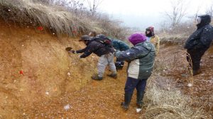
27 June 2017– The Eastern Tennessee Seismic Zone (ETSZ), a zone of small earthquakes stretching from northeastern Alabama to southwestern Virginia, may have generated earthquakes of magnitude 6 or greater within the last 25,000 years, according to a study published in the Bulletin of the Seismological Society of America. … Continue Reading »
Call for Papers: SRL Focus Section on Non-explosive Active Source Monitoring and Imaging
30 May 2017 – Seismological Research Letters (SRL) announces a Focus Section on “Non-explosive active source monitoring and imaging.” This SRL section will focus on new developments of non-explosive active sources, data processing, subsurface imaging and monitoring with non-explosive active sources, and their contribution to the advancement in earthquake, tectonic/volcanic, and environmental sciences as well as their social impacts.
SSA Announces 2017 Award Winners

24 May 2016 – SSA is pleased to announce the recipients of several of the Society’s awards for 2017. The winners of the Harry Fielding Reid Medal, the Charles F. Richer Early Career Award, the Frank Press Public Service Award, and the Distinguished Service to SSA Award are among the highest honors conferred by the Society.
Congratulations to Reid Medal recipient George Plafker; Richter recipient Annemarie Baltay; Press Award recipient Lori Dengler; and Distinguished Service recipient Keith Knudsen.
Call for Papers: BSSA Special Issue: Fifty Years after the 1967 Koyna Earthquake: Progress in our understanding of Reservoir Triggered Seismicity (RTS)
4 May 2017–The Bulletin of the Seismological Society of America (BSSA) is soliciting papers for a Special Issue on Reservoir Triggered Seismicity. December 10, 2017 marks 50 years since the 1967 magnitude 6.3 Koyna earthquake in western India, recognized as the world’s largest Reservoir Triggered Seismic (RTS) event.

